Uh, where's all the snow? I could see, even from more than 50 miles away, that the north face, the most shaded aspect of the mountain, was almost void of snow.
A guy at The Fifth Season, the climbing shop in Mount Shasta City, said it was the lowest snow year in 30 years. He looked at me like I was nuts when I told him I'd come from Montana to ski. "If you wanted to ski," he told me, "you probably should have stayed home." Well, I've come a long way, I told him, I don't care how bad the skiing is, I just want to summit and I want to ski something. "Survival skiing in fine." The guy called the owner of the shop over and asked him what he thought. The owner frowned and quickly and curtly told me no way. "There's exposed rock everywhere and four foot deep sun cups. Totally un-skiable." Well, I told him, though discouraged, I'm here, I may as well find out for myself. I bought the $20 permit required for travel above 10,000 ft.
I went to the grocery store, got some food supplies, went to The Goat, a bar in town, for a beer and fish tacos, and drove up the 10-mile road to Bunny Flat, the lowest staging point on the mountain.
In March, I'd assumed I would put my skis on in the parking lot and be able to skin almost 5,000 of the 7,000 ft. ascent to the summit. On June 10, there was no snow in sight. I talked to two guys in the parking lot who had climbed that day. (While most people split the climb into two days, camping at around 11,000 ft., some do it in one. I had always planned on doing it in one.) They told me it would be almost 3,000 ft. before I'd hit the snow line. Is it skiable? They said they didn't know, they'd never skied before. While a few tourists milled around the parking lot, taking pictures of the peak, no one else came down or seemed to know anything. I got my gear together, I made food, I relaxed, I read. As the evening wore on, a dense fog enveloped the mountain and slowly descended on the parking lot, obscuring even the pit toilet only 20 ft. away. I began to question whether this was a good idea. Climbing a peak that I'd only ever Google Earthed and now couldn't see seemed like a really bad idea.
At around 8, a guy, a Shasta Guide, and a girl came down off the trail. (Note: Shasta Guides will Sherpa your stuff over a two-day trip. For $600. Wow.) The guy seemed excited about my idea to ski. He said it would be survival skiing, but if the snow was soft enough, I could definitely find some good lines. Finally, some good news. Can I make it to the summit to ski? He laughed and said I could carry them to the summit if I wanted, but I'd have to carry them most of the way down, too: The sun-cuping up The Heart was beyond bad; the notch in the Red Rocks is about 300 feet long, five feet wide, and pure ice; there is no snow at all the last 500 feet to the summit. It would be a pain, he told me, but you can carry your skis up to about 11,000 ft., drop them, summit, and ski 2,000 feet down on your way back to Horse Camp. I told him about the owner of Fifth Season telling me it was totally un-skiable. He frowned. "Oh, those guys are just super conservative."


I woke up at 3:30 a.m., made some oatmeal and tea, and was on the trail, skis and boots lashed to my pack, by four. I could see faint stars in the sky; the clouds were clearing. I walked the two miles up the Horse Camp trail in the dark, headlamp leading the way, and started off trail up Avalanche Gulch. I gradually climbed out of the inversion and above the clouds as the sun began to rise, the sky slowly transitioning from black, to purple, to navy, to lighter blue. It was going to be a perfect day to climb. At around 10,000 ft. I hit consistent snow and traded trail running shoes for ski boots and crampons. The sun-cuped snow refroze overnight and was a mangled, mounded, icy mess. Skinning would be impossible. I have never seen such un-skiable snow. Maybe The Fifth Season guy wasn't kidding? I started the steady climb, booting up to Lake Helen, a tiny glacial lake, totally frozen, that you wouldn't know was there if it wasn't on a map. I passed the first three descending climbers of the day. I said good morning, they walked past me without acknowledging me. I kept slowly climbing. I was amazed at how slow I was moving; I couldn't move more than 20 feet without stopping, the weight of my pack and the altitude sapping my energy. Above me there were about six climbers descending through The Heart, the first steep portion of the climb, a 1,500 ft., 40-degree pitch. I talked to the first guy I passed. He said he had spent the night at Lake Helen and started climbing at 3 a.m. Everyone above him had done the same. I looked back into the valley and saw no one. I would probably be the last climber of the day. I asked him if it was worth carrying my skis any higher. No way. I climbed another 200 feet and finally dropped the skis and ski gear on an outcrop of exposed rock and covered the gear with rocks incase the wind picked up.


I began my ascent of The Heart, feeling much better without the skis and boots weighing me down. I slowly climbed and passed a few people descending The Heart. About halfway up, about 500 ft. above me and another descending climber, a guy started to try to glissade and kicked off a few huge hunks of ice. We yelled for him to stop, he didn't respond. Again, he tried to glissade, again kicking off more ice, and again didn't yell or seem to care. I ducked and covered my face as a softball-sized piece of ice whizzed about two feet past my head. We yelled again, this time louder and meaner, and this time he acknowledged us, waved, and stopped. As I got closer to him his partner yelled at me, "What's your problem? Why are you being a jerk?" A jerk? What? "Your partner is kicking ice onto people," I yelled as kindly as I could, "you're not being safe. Someone is going to get hurt." My rationale seemed to calm him, his tone quickly changed. He apologized and asked me how my day was going.

As I ascended The Heart toward Red Rocks, I passed two more people who didn't even turn to look at me. At the time I thought the people I'd passed, these "mountaineers," were being jerks. It wouldn't be long until I'd know the feeling, too.

I had watched the descending climbers all downclimb through the same narrow chimney in Red Rocks, a 30 ft. high, quarter-mile long wall at the top of The Heart. The chimney was narrow and steep and covered with loose rock and a thin sheet of hard-packed, frozen, mangled snow. The climb would be precarious, but okay, but I was already aware that the downclimb, especially through the narrowest sections, would be a no-fall zone. I looked down into the valley, still no one in sight; I was definitely the last climber on the mountain for the day. I sat at the base of the chimney for a long time trying to decide what I should do. Up or down? I came here to ski, not do this. I ultimately focused on the fact that I had eight more hours of light, and, slow and steady, I could do it safely. The snow would probably soften in the intense sun. I slowly climbed through Red Rocks, crampons keeping me attached to the mountain, whip-it in one hand, ice axe in the other. Step, step, swing, thump, step, step, pull out, swing, thump, repeat. I slowly and carefully ascended through Red Rocks, too focused to think about the altitude. The last 300 ft. of the chimney widened and I was able to climb without an axe. As the climb mellowed and my adrenaline subsided, I finally started to feel the altitude. I was at 13,600 ft., everything began to feel weird.

I topped-out the chimney and saw Misery Hill, the last 500 ft. to the summit, a straight-forward, simple scree hill, totally void of snow. I knew Misery Hill has two false summits; I was mentally prepared, but I felt epicly miserable. Every symptom of altitude sickness was coursing through me: I felt like I was going to throw up, my head ached, I was deliriously tired, I was coughing a lot, my fingers, toes, and lips were swelling with the onset of peripheral oedema. I began the long slog up, one foot in front of the other. I've never walked so slowly in my life. It felt strange to go through the entire climb only to finish with a 500 ft. scree trail to the summit and be in more agony than I'd been at any other point of the climb, in any climb. I slowly walked, every step wanting the experience to be over.


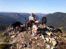
When I got to the Misery Hill plateau, the second false summit, and I finally saw the true summit, I was sick of it. I felt so awful, and scared, that I didn't care, I didn't want it. I was so tired I was afraid to sit down, thinking I would fall asleep. I took a sip of water and forced myself to eat a bite of a peanut butter and jelly sandwich. I stood there for less than a minute, no more than 150 ft. shy of the summit, took one photo, and turned around.


I started to downclimb through the Red Rocks chimney, feeling a little better with each step down toward sea level. My fingers and toes still ached, but I was more awake and aware. In the hour or two since I'd climbed out of the chimney and back, the snow hadn't softened like I'd hoped. This was what I had I had been scared of. I walked across the top of the Red Rocks to see if I could find an alternate route out. Nothing. The way in was the only way out. I started to downclimb through the narrowest section; it was like descending a ladder without rails or rungs. Step, step, swing, thump, step, step, pull out, swing, thump, repeat, only this time slower and more deliberately. A few times I'd swing and instead of thump, I'd hear the clang of metal on rock and I'd have to swing two or three more times until I found that thump again. The snow was so hard I could only kick the three front spikes of my crampons in with each step. I thought about how people do this every Saturday recreationally, for fun. There was nothing fun about it. Why would anyone do this for fun? If I slipped, it was over. I promised myself I'd never put myself in this position again.

At the base of Red Rocks I made my way to the glissade track, a two ft. wide, two ft. deep, concrete water slide ass-carved in the snow. It had taken me about an hour to climb The Heart; it took me less than 10 minutes to descend it.

I retrieved my skis at the rock outcrop, put my skins on, and skinned across the bowl above Lake Helen to the shoot that looked the least sun-cuped. I ripped skins and skied. I'd find a great 200 ft. line of perfect corn and then have to put the breaks on, carefully skiing the next 100 ft. around the sun cup craters and soccer ball-size rocks. I made it almost 2,000 ft. before I ran out of snow. I passed about a dozen people on the way down; I was too tired to acknowledge any of them.

Above Horse Camp, I transitioned from ski boots back to shoes, lashed my ski gear to my pack again, and slowly walked the two miles back to Bunny Flat. When I got to the car it was 3 o'clock; about 13,000 ft., round trip, in about 11 hours. I packed my gear into the car quickly, texted a few people to let them know I'd made it out safe, and drove down, eager to get back to town for a beer.
The bartender at The Goat asked me if I'd climbed it. I told him yes. He asked me how it went. I didn't tell him the details, I just said that I was never doing anything like that again.


